
|
|
||||||||||||||||||||||||
|
Alaska's Heritage
CHAPTER 4-2 OVERLAND EXPLORATION
Large areas of Alaska are unexplored Ten years after the Alaska purchase, Americans knew little more than the Russians had known of what lay beyond the coast of Alaska. Encouraged by gold discoveries in the Canadian Cassiar and near Sitka, and rumors of Doroshin's discoveries of gold in Southcentral Alaska, prospectors set off into Alaska's wilderness. Few left written reports of their travels. Those who did encouraged the government to send explorers to Alaska. Alaska challenged explorers with almost every environment found elsewhere in North America. There were swift rivers, timbered valleys, swamps, mountains, and muskeg. Big game animals, such as bear, and insects, particularly mosquitoes and no-see-ums, provided other challenges to explorers. Explorers came to Alaska for a variety of reasons. There was a need for accurate coastal charts and maps. During the late 1800s, ethnological research was popular. Traders, trappers, and prospectors wanted access routes to fur and mineral resources. Tourists wanted to see the wonders of the country. Finally, studying Alaska's geology and environment was of interest to scientists. Nelson explores western Alaska Members of the Western Union Telegraph Expedition had collected ethnological materials from Alaska for the Smithsonian Institution. William Healey Dall, an expedition member, continued this work in the 1870s while working for the U.S. Coast Survey along the Aleutian Islands. Other government representatives assigned to Alaska and some private individuals collected materials for museums in the United States and Europe. Among them was Edward W. Nelson. In 1877, Nelson, a private in the U.S. Signal Service, was stationed at St. Michael to collect weather data. In winter, 1878, he crossed the Yukon-Kuskokwim delta to the Kuskokwim River. There he did invaluable research work among the Yupik Eskimos and collected many ethnographic items for the Smithsonian Institution. He made several other journeys before he left Alaska in 1881. Later, he published reports to accompany the ethnographic collections. They included much information about the geography and villages of Western Alaska. Petroff takes the census In 1880, the United States government wanted to determine how many persons were living in Alaska's outlying country. The Census Office appointed Ivan Petroff to take the first American census of Alaska. Petroff traveled around Alaska during the summers of 1880 and 1881. It was impossible for him to visit every part of the territory. He did visit Cook Inlet, Kodiak Island, the Shumagins and other islands south of the Alaska Peninsula, a portion of the Aleutian Islands, lower portions of the Yukon and Kuskokwim rivers and some of the Bering Sea coast. In 1884, Petroff's Report on the Population, Industries, and Resources of Alaska was published by the Government Printing Office in Washington, D.C. The report was reprinted twice before the end of the century. Petroff's third chapter was devoted to Alaska's geography. Most of the information was about coastal areas. Large sections of Alaska remained unexplored. Rumors bring the army No one was more aware of the lack of information about Alaska than General Nelson A. Miles. He was responsible, in the 1880s, for United States Army activity in the new territory. Congress refused to fund large-scale army exploration of so vast a land containing so few inhabitants. Nonetheless, when Miles heard that Native trappers on the Yukon River were unhappy because of a drop in fur prices he dispatched First Lieutenant Frederick Schwatka to investigate in 1883. 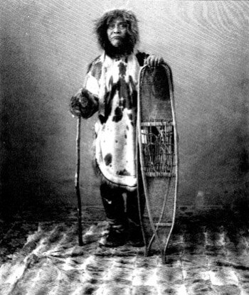 Ind-a-yanek, Schwatka's Native guide, on the 1883 expedition. Collection Name: Alaska Historical Library, Case and Draper Collection. Identifier: PCA 39-287 In 1885, both official and popular versions of Schwatka's journey were published. The wide publicity did not help Genera) Miles obtain exploration funds. Schwatka did not explore new territory. He did, however, gather much useful information on the inhabitants of the upper Yukon River. Abercrombie attempts to reach Interior Alaska from Southcentral Alaska Schwatka's route passed through Canadian territory. Americans were interested in a route to the Yukon River that did not cross through foreign territory. It was thought that such a route existed from Southcentral Alaska to the interior. In time, such a route from a year-round ice-free port to the Yukon might be an important transportation and supply highway. The Copper River valley, appeared as though it might be such a corridor. General files chose Lieutenant William R. Abercrombie to explore the Copper River in 1884. His primary mission was to determine Native reaction to the prospectors who were beginning to enter the region. Abercrombie and his party began their difficult journey up the Copper River in June of 1884. They rowed and pulled their boats upstream. The water was so cold that the men could pull the boats for no more than 15 or 24 minutes before letting go of the towlines to warm up by running up and down the bank. One of the party's small canoes was crushed by icebergs discharged from glaciers they encountered. The lieutenant and his men turned back in July. Abercrombie was convinced the glaciers and rapids made the Copper River route impractical. He suggested the Susitna, a river he had never seen, as the means to enter the Interior. Allen completes remarkable journey Instead of following Abercrombie's suggestion, army superiors sent Lieutenant Henry T. Allen to try a Copper River ascent the next year. With $2,000 the army allocated for the expedition, Allen outfitted himself, Private Frederick w. Fickett, and Sergeant Cady Robertson. John Pederson, a trader, joined the party at Nuchek. They succeeded where Abercrombie had failed. One reason was that they started earlier in the year and ascended the lower reaches of the river before the ice broke. The Allen party began its journey on March 29. The lieutenant and his companions traveled by sled and by snowshoe, carrying canoes to use when the rivers were free of ice. A little more than a month later the party arrived at the Ahtna village of Taral, two miles south of the junction of the Copper and Chitina rivers. Taral consisted of two houses, and one of them was empty. The other was occupied by a prospector named John Bremner, who welcomed them enthusiastically and fired his last round of ammunition in answer to Allen's salute. Allen described the prospector as "a picture of wretchedness, destitution and despair" who was near starvation. The explorers could do little to help Bremner. They were nearly out of food themselves, their diet having been reduced to "snowballs and rabbit tracks." From Taral, Allen and his men, joined by Bremner, went up the Chitina River to the camp of Nicolai, an Ahtna chief. The mission might have failed had it not been for this 18-year-old Ahtna chief. Although he had forbidden his people to trade with non-Natives, Nicolai did not hesitate to share the tribe's meager food with the explorers. Nicolai showed Allen copper utensils that his people used, bullets they made of a copper and silver alloy, and pure copper nuggets from a vein that he claimed to own. Nicolai guided Allen and his party back down the Chitina River and then up the Copper River to the limits of his territory. The Ahtnas they encountered along the river have the party little information about a route to the interior. The Ahtnas did not want to share their knowledge of routes because it might endanger their role in the trade between interior and coastal Natives. Allen continued north through the unmapped country. On June 5, 1885, the party crossed Suslota Pass into the Tanana River valley. The party followed the Tanana River to its confluence with the Yukon, then traveled down the Yukon to the Koyukuk River. After investigating the Koyukuk to a point north of the Arctic Circle, they main followed the Yukon and reached St. Michael at the end of August. 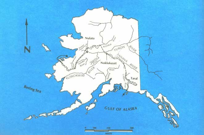 Route of the 1885 Allen expedition. Sailors explore the Kobuk River The same year that Schwatka explored interior Alaska, the navy began to explore in Northwest Alaska. in 1883, the Revenue Cutter Corwin steamed north to deliver gifts to Siberian Eskimos who had clothed and fed survivors of the navy ship Rodgers, that had burned off the coast of Siberia while searching for a missing ship, the Jeannette. U.S. Navy Lieutenant George M. Stoney presented the gifts. After delivering the gifts, the Corwin began a cruise in arctic waters. When the revenue cutter reached Kotzebue Sound, Stoney took a small boat and one crew member to explore Hotham Inlet. During this week-long investigation a Native told Stoney about a river that flowed north into an ocean filled with ice. Stoney thought this might be the Colville or MacKenzie rivers that possibly could be reached by a short portage from the headwaters of the Kobuk River that flowed into Hotham Inlet. Such a route could be very important to future efforts to rescue people stranded on Alaska's arctic coast. Stoney was a navy lieutenant. Healy, the Corwin's captain, was an officer of the Revenue Marine Service. Both proposed future explorations of the Kobuk River by their respective services. As a result, in 1884 both the navy and revenue cutter service launched expeditions u p the Kobuk River. Healy dispatched Revenue Marine Service Lieutenant John C. Cantwell upriver. He brought back a report on the resources of the region and searched for the deposits of jade which Natives of that area traded. Cantwell's party took a steam launch and then an umiak 300 miles upstream before turning back. Although he did not reach the Kobuk River's headwaters, Cantwell learned of portages to the Koyukuk River and perhaps also to the Colville River. In his report he pointed out the importance of such routes for rescue purposes. Stoney, who had arrived at the mouth of the river on the naval schooner Ounalaska and started upriver later, passed Cantwell coming down-river. As had Cantwell, the navy party took a small steam launch part way and then transferred to skin boats. Stoney and his men also did not reach the headwaters of the Kobuk River in 1884. The following summer, Cantwell and Stoney continued their rival explorations. Cantwell reached walker Lake, where the Kobuk River begins. While he was ascending the Kobuk River, S.B. McLenegan, a companion officer on the Corwin, took one crew member in a kayak up the Noatak River to that river's headwaters. The revenue service expeditions brought back important natural history information about the regions they had investigated and McLenegan's map of the Noatak River remained in use until the end of the century. Again in 1885, Cantwell passed Stoney coming upriver as he went downstream. The navy party was equipped for a major expedition. A steam launch, 60-foot steamboat, and steam sawmill were included in the outfit. The navy men established a base camp, which they called Fort Cosmos, well up the Kobuk River. From this base, for over two years, Stoney investigated the headwaters of the Kobuk, Noatak, and Alatna rivers. A party led by Ensign William L. Howard went, north by dog team across the Noatak River to the Colville River, down the Chipp River to Dease Inlet on the Beaufort Sea, and on to Point Barrow. Engineer Officer Abraham V. Zane traveled down the Koyukuk River to the Yukon River and St. Michael. The explorations by competing services made the Kobuk River region one of the better known areas of Alaska. Competition had produced good results. Stoney's well-planned and systematic investigations from Fort Cosmos served as a model for later Arctic and Antarctic explorations. Wells expedition captures public imagination In 1890, W.J. Arkell, publisher of a popular weekly, Frank Leslie's Illustrated Newspaper, commissioned E. H. Wells to head an exploring party to Alaska. Wells, a newspaper reporter, had mapped the Fortymile River and rafted the Yukon River in 1889 on assignment for the E. W. Scripps newspapers. Although the expedition's purpose was to provide accurate information about Alaska, the publisher hoped that ells would send back exciting stories. The team included E. J. Glave, an artist who had spent six years in Africa with Dr. Henry Stanley, and Alfred B. Schanz, a Mew York reporter. In San Francisco, Jack Dalton, a mountaineer who had been to Alaska, and Frank B. Price, a sailor who had been to the arctic, were hired. The U.S. Coast Guard and Geodetic Survey supplied the party with instruments and transportation to Alaska. The Patterson left San Francisco on April 10, 1890, and three weeks later landed the explorers at Pyramid Harbor on Lynn Canal at the mouth of the Chilkat River. Here the group added Duckaskinaw Sinquoquada, a Chilkat Tlingit whom the others called "Indiank." He had been with Schwatka in 1883. The Chilkat chief permitted the party to cross Chilkat Pass. In May and June the party explored the Chilkat valley and reached the Yukon River. The expedition's original plans were to ascend the Fortymile River, portage to the Tanana River, and ascend the Tok River to the headwaters of the Copper River, then follow that river to the coast. Early in June, Glave and Dalton separated from the main group to explore the Alsek River. Before starting on the journey, Glave wrote about the Tlingits of Klukwan. By dividing, the group covered more territory. Instead of following the Copper River, Wells and Schanz went down the Yukon River. They crossed the water portage from the Yukon to the Kuskokwim river drainage. At trader Linn's post near the mission station at Bethel, they enjoyed a meal served "civilized fashion at a table." The two men continued their trip in small canoes to Nushagak. There at the Alaska Commercial Company trading post operated by John Clark, Wells built a 12-foot sled for an overland journey across the Alaska Peninsula to Katmai Station. While wells was crossing to Katmai by sled, Schanz, accompanied by Clark and seven Eskimos from Nushagak, ascended the Nushagak, Mulchatna, and Kakhtul rivers, portaged to the Holitna River, and traveled to Lake Clark, which they named for the trader. Schanz rejoined Wells at Kodiak and from there they returned to Seattle. Although the newspaper-sponsored expedition did not report much scientific information, the accounts were popular and widely read by the American public. Dickey names Mount McKinley Although many did not, some prospectors left accounts of their travels. One was William A. Dickey, who participated in a gold stampede to Southcentral Alaska in 1896. As Dickey and his partner, Allen Monks, explored the Susitna River valley, they saw in the distance a mountain whose huge peak 'towering far above the high rugged range encircling its base . . . compelled our unbounded admiration." Dickey learned that the Athabaskans of Cook Inlet called the peak Bulshoe, a word derived from the Russian word bul'shaia, which means big. Other Athabaskans knew the mountain as Denali, meaning high one. Dickey, however, named the giant mountain McKinley to honor the man who soon would become the nation's twenty-fifth president. The following year Dickey published a crude sketch map of the Susitna River. At that time few persons were interested in using the river as a transportation route to the interior. It offered neither a direct nor an easy passage to the gold fields of the upper Yukon River. The army seeks an all-American route to the Yukon Following the discovery of gold in the Klondike, the public demanded more information about Alaska. The army ordered several expeditions to Alaska in 1898 to learn more about potential routes to the Yukon River. Captain Abercrombie, who had attempted to ascend the Copper River in 1884, received orders to return and explore the Copper River area for a land or water route. At the same time, Captain Edwin F. Glenn was directed to cross from Prince William Sound to Cook Inlet and seek the best way from there to the Yukon River. Detachments from Glenn's party investigated several routes from Portage Bay in Prince William Sound overland to Cook Inlet and trails along the Susitna and Matanuska rivers to Interior Alaska. Only one party reached the Yukon River. It traveled from the trading station known as Knik on upper Cook inlet up the Matanuska River, and from there past Lake Louise to the Delta and then the Tanana rivers. Glenn concluded that this was a feasible railroad route but added that it was premature to contemplate such construction. Abercrombie and his men investigated a prospector's trail that went over Valdez Glacier and then down tributary streams to the Copper River. One party led by Abercrombie went as far north as Mentasta Pass, which led to the Tanana and Fortymile rivers and by they to the upper Yukon. The captain recommended construction of a military trail from Valdez north to the Yukon River. Another 1898 expedition, led by geologist Josiah E. Spurn, went from upper Cook Inlet through the Alaska Range, to the headwaters of the South Fork of the Kuskokwim River, then down the Kuskokwim River. Spurr's party started up the Susitna River from Cook Inlet in three canoes in late spring when there was still ice on the river. As they worked their way over the Alaska Range, Spurn and his men drew maps, collected plants, and studied the wildlife and geology of the country. From the headwaters of the South Fork, the party went down the Kuskokwim River in the canoes they had transported across the mountains. When they reached Bethel, Spurn changed his plans. Instead of crossing to the Yukon River and going to St. Michael, part of the team headed for Bristol Bay. Half of the group, led by Spurn, followed the Kuskokwim River to its mouth. With local Eskimos as guides they went up the Kanektok River then portaged to Togiak. From Bristol Bay they followed Wells' route to Katmai Station. Alaska's geography is essentially known by 1900 In the years between 1867 and 1900 the Americans did a competent job of amassing knowledge of Alaska. The overall geography of Alaska had been established by 1900. This does not mean Alaska was completely explored and mapped. It does mean that important mountain ranges had been outlined and the major rivers traced. In 1900, the U.S. Geological Survey took over as the major government agency devoted to scientific exploration. The army was less concerned with exploration after that, although it continued other activities in Alaska such as road and trail building and the maintenance of order. The navy was occupied with communication activities. The Coast and Geodetic Survey was confined to mapping the coast. The Revenue Marine Service did not venture inland after the Yukon River steamer it operated during the peak years of gold rush activity was decommissioned. Significantly, the American explorers of Alaska made the information they gathered widely known. This helped Alaskans get more attention from the federal government and attracted more people to Alaska.
|
|||||||||||||||||
|
