
|
|
||||||||||||||||||||||||
|
America's Territory
Overland Routes Develop
Alaska's Native people used many trails before Europeans arrived - trails which the Russians American traders and prospectors then used as well. Much travel over trails was during the winter when frozen rivers were part of the routes. 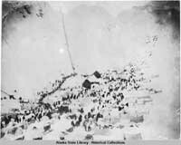 Chilkoot Summit Tents and people, trail leading up through snow. Prospectors still wanted an easier overland route between an ice-free port in southern Alaska and the Yukon River. The Army sent parties to investigate the Susitna, Matanuska, and Copper River valleys. The best route appeared to be north from Valdez, through the Copper River valley.. The Army started to build the trail in 1899 and called it the Trans-Alaska Military Road. A few years later a Senate committee studied Alaska's transportation situation. The committee recommended that the War Department build a system of trails in Alaska and upgrade the Valdez-Eagle trail to a wagon road. To pay for the work, Congress authorized use of 70 percent of the business license fees collected in Alaska. Men living outside of towns gave two days labor or eight dollars cash toward road-building each year. Congress also created the Alaska Road Commission (ARC), to oversee construction and maintenance of roads and trails. 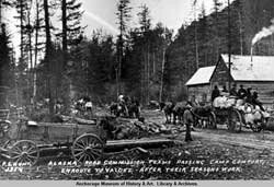 Alaska Road Commission team Alaska Road Commission teams passing Camp Comfort enroute to Valdez after their seasons [sic] work. 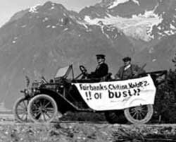 Automobile with banner: Fairbanks. Chitina. Valdez!! or bust!! View of men riding in Model T Ford with banner, Valdez-Fairbanks Trail, Valdez, Alaska. The federal government created the Tongass and Chugach national forests in Alaska in the early 1900s.The Department of Agriculture contracted with the ARC to do its road work until 1922 when its Bureau of Public Roads took responsibility for constructing roads and trails in the forests. Between 1905 and 1932, the ARC built 1,231 miles of roads, 74 miles of tram road, 1,495 miles of sled roads, 4,732 miles of trails, 329 miles of temporary flagged trails, 26 airfields, and 32 shelter cabins. The total cost was over $18 million. The Department of the Interior required all vehicles in Alaska to be registered and to pay license fees. Commercial vehicles on the Richardson Highway had to pay a toll.. Even with tolls between $100 and $175, cars and trucks had much lower costs than the railroad. Nonetheless, truckers resented the tolls and in the 1940 established their own ferry at Big Delta on the Tanana River where the toll was collected, in an attempt to avoid paying the fee. 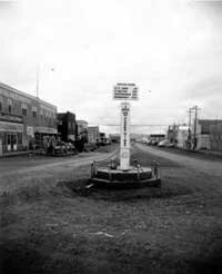 Alaska Highway mile 0 sign, Dawson Creek, B.C., 1949 Sign on the marker reads "Mile 0 Alaska Hiway". In 1956, the ARC was transferred to the federal Bureau of Public Roads. The transfer was significant because Alaska would now receive funds under the Federal Aid Highway Act. When Alaska became a state it took over maintenance of over 3,100 miles of roads. One of its first projects was construction of a new Fairbanks to Anchorage road, the George Parks Highway. After the 1964 earthquake damaged many roads in Southcentral Alaska, the state had to do major repairs. After the Prudhoe Bay oil discovery, the state built a road from Fairbanks to the North Slope. Discussion of roads from Fairbanks to Nome, from Skagway to Juneau, and of a Copper River Highway still continue.
|
|||||||||||||||||
|
