
|
|
||||||||||||||||||||||||
|
Alaska's Heritage
CHAPTER 1-1: GEOLOGICAL AND GLACIAL HISTORY
Introduction 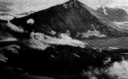 Mountains and lowlands are part of Alaska's topography. Collection Name: Alaska Historical Library, Fr. Bernard R. Hubbard. Identifier: PCA 302-599 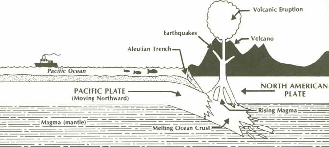 The movement of huge plates over the earth's soft interior continues to change the world's landscape. The sliding of the Pacific plate beneath the North American plate particularly affects Alaska. This movement can trigger earthquakes and volcanoes. The land changes constantly Geology is the study of the earth and its components. From their studies, most geologists believe that the earth's outer shell is made up of twelve huge plates that slowly drift over the earth's soft interior. These plates are termed continental or oceanic. Continental plates contain a continent that rides on top of the plates; oceanic plates are composed entirely of ocean floor. These geologists think the plates are each about 60 miles thick. As the plates move they slide past, slide beneath, or collide with each other. The name given to this concept is plate tectonics. From studies of Alaska's volcanoes, earthquakes, and landscapes, some scientists argue that Alaska was created when two continental plates ran into each other. When the plates collided the continents riding on top of them merged into a single, much larger, continent. Other geologists believe Alaska was pieced together from parts of at least seven plates that collided and fused over a long period of time. They think that the pieces were added at different times. Both groups agree that Alaska's major features were shaped about 125 million years ago. These geologists explain that today Alaska is influenced by the movements of two major plates. They say that the northward-moving Pacific oceanic plate is slipping under the North American continental plate. the place where the Pacific plate bends to slide under the 60-mile thick North American plate is called the Aleutian Trench. The Aleutian Trench is and underwater trough more than 2,000 miles long, 20 to 100 miles wide, with a maximum depth of over 25,000 feet. This trench is one of the lowest parts of the Pacific Ocean floor. As the Pacific plate slides beneath the North American plate it begins to melt from the heat generated in the earth's interior. Molten rock rises through the North American plate until it reaches the surface and erupts in volcanoes. Glaciers cover large parts of Alaska 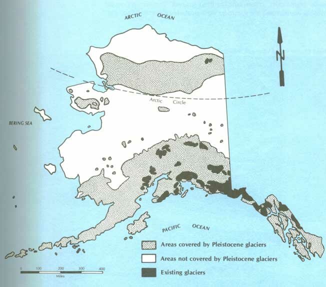 During the Pleistocene ice age, glaciers covered large areas of Alaska. Large glaciers can still be found in these areas. Two areas of Alaska, the interior lowland and arctic coastal plain, were not covered with ice during the Pleistocene. During the Pleistocene, sea level was so much lower that land connected North America and Asia. This land bridge and unglaciated areas of Northeastern Siberia, Interior Alaska, and Northwest Canada are referred to as Beringia. Interior Alaska was a grassland where woolly mammoths, bison, and caribou grazed. The winters were probably warmer and the summers were probably drier than they are now. As glaciers melted, sea level rose. The land bridge gradually flooded. Long before the Bering Sea completely separated North America and Asia, around 9,000 years ago, ancestors of American Indians had moved east across Beringia. These people were hunters seeking more plentiful game. Even though some of Alaska's glaciers melted entirely during the warming trend that began thousands of years ago, ice fields are still found in northern Southeast and eastern Southcentral Alaska. They cover 28,800 square miles, or 4.9 per cent of Alaska's total land area. Malaspina Glacier is larger than the state of Rhode Island. Washington, D.C. could fit on Prince William Sound's Columbia Glacier.
|
||||||||||||||||
|
