
|
|
||||||||||||||||||||||||
|
The Geography of Alaska
Physical Geography
Four separate, yet interrelated components make up Alaskan environment:
The processes operating in these four spheres are interlinked to varying degrees. Together they have created, and continue to create, the physical landscape that makes up Alaska. That is why geographers refer to these processes as part of a physical system. However, for ease of understanding we will look at these processes separately. Lithosphere: Landforms 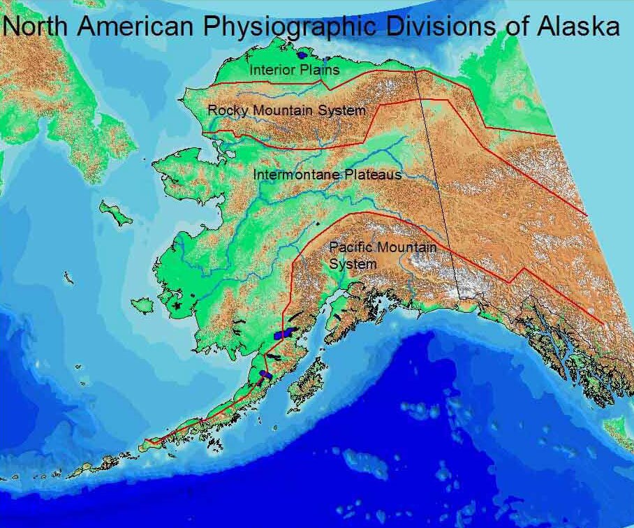 Figure PS.1 - Physiographic Regions Collection Name: Pearson, Roger and Marjorie Hermans. (Eds.) 2001. Alaska in Maps. Anchorage: Alaska Geographic Alliance, Map 11. The Pacific Mountains and Valleys adjoin the Pacific Ocean and constitute the area where most Alaskans live. This region is part of a greater North American system that extends from Mexico through the conterminous US and Canada and then arcs to form the northern boundary of the Pacific Ocean. Here we find the great mountains of Alaska, dominated by Mt. McKinley (20,320 feet; 6,194 meters) in the Alaska Range. This region also contains important troughs such as the straits and sounds of Southeast Alaska, Prince William Sound, and the Cook Inlet Lowlands. Alaskas second mountain system, composed primarily of the Brooks Range, is actually a northward extension of the Rocky Mountain system. Geologically older than the Pacific Coastal system, the mountains of this region are much smaller in height with the highest peak, Mt. Chamberlin, extending to 9,020 feet (2,749 meters). Also whereas the Pacific system arcs northward, this system arcs southward. Lying between the two great mountain systems, as its name implies, is the Intermontane Basin and Plateau region. This area contains highlands such as the Yukon-Tanana Uplands, the Kuskokwim Mountains, and the Ahklun Mountains. It also contains the largest river systems in Alaskathe Yukon, as well as the vast Yukon-Kuskokwim coastal lowlands that forms the delta region of the two rivers. Lastly, the Arctic Coastal Plain which borders the Arctic Ocean, is the northwestern extension of the Interior Plains physiographic region. While the smallest of the physiographic units, it is also the most important in terms of mineral fuel production for here are the great petroleum reserves of Prudhoe Bay and related fields. 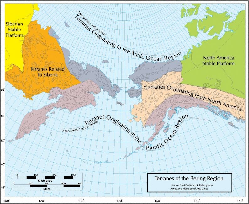 Figure PS.2 - Terranes of the Bering Region Lying southward off the coast of Alaska is the Aleutian Trench which descends to nearly 5 miles (8 kilometers) below the surface of the Pacific Ocean. The Aleutian Trench is an area where the geological structures of the Pacific Plate are subducting (diving down) below the geologic structure of the North American Plate. This is a slow processmoving at approximately 2 inches (5 centimeters) per year. While that might seem as exciting as watching your fingernails grow, over millions of years the impact of this movement is enormous for it creates the mountains and valleys that make up Alaska and during brief moments it announces that action through earthquakes and volcanic explosions. Atmosphere Why is the climate of Barrow not like Ketchikan? This is a reasonable question and it requires us to look at the underlying factors that make up the climate of an area. Climate is the average weather of an area over a period of years. There are several factors that influence the climate of an area. Here we will look at only a few. Then we will look at the overall pattern of climate. Latitude. Undoubtedly, a major factor influencing Alaskas climate is that of latitude. Most of Alaska lies north of 600 meaning that sun angle (degrees above the horizon) is going to be fairly low. Consequently, incoming solar radiation will be limited making Alaska cold. Northern latitudes also experience great seasonal differences with long periods of summer light and long periods of little winter sunlight. In the case of our two examples, at Barrow the sun does not rise above the horizon from mid-November to late January whereas Ketchikan has over six hours of sunlight on December 21, its shortest day. On June 21, the sun reaches approximately 42 degrees above the horizon whereas in Ketchikan it is about 58 degrees above the horizon. Land and Water. Large water bodies such as oceans heat and cool more slowly than land areas. As a result, coastal areas tend to have less seasonal extremes than interior or continental areas. Fairbanks, for example has a maximum average July temperature of 72° F. and a minimum average January temperature of -20° F. In contrast, coastal Juneau has a maximum average July temperature of 65° and a January minimum of 18° F. Continental areas such as Fairbanks also tend to have less precipitation than coastal areas as they are further away from sources of moisture. Other Factors. Other environmental factors also influence the climate of an area. The presence of mountains in Southeast Alaska accounts for areas of high precipitation and areas of relative dry which lie in the rain shadow area of the mountains. Areas with cold temperatures like Barrow tend to have little atmospheric moisture especially when they are dominated by stable air pressure for long periods of time. Using our two examples, Ketchikan has over 13 feet of precipitation a year whereas Barrow has about 5 inches. 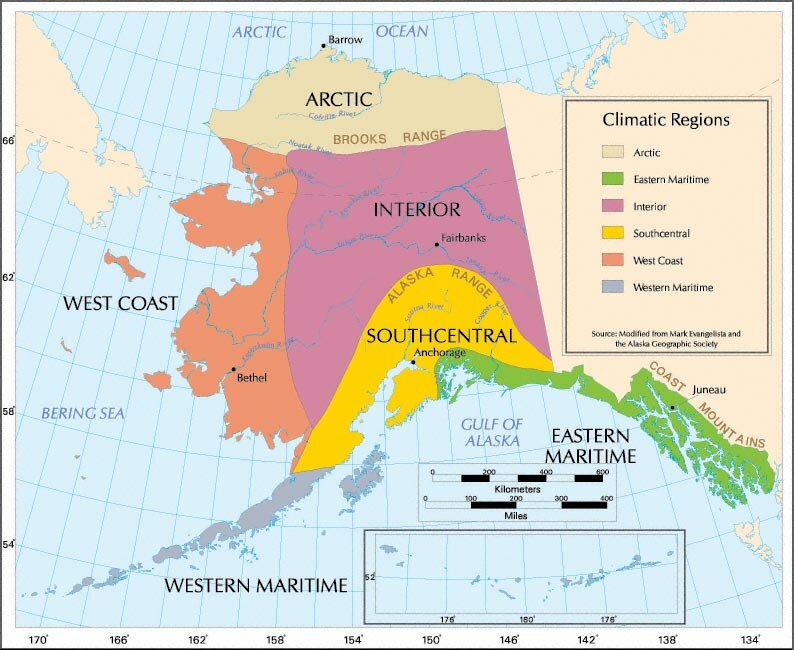 Figure PS.3 - Climatic Regions By combining the average temperature and precipitation conditions of various communities of Alaska, we can develop some general climatic regions as those shown in Figure PS.3. The boundaries of each of these regions should not necessarily be thought of as sharp lines of contrast as was discussed in the section on regions. A comparison of climographs, which show average monthly temperature and precipitation conditions, of communities in each of the regions does demonstrate the contrasting climatic conditions. Hydrosphere During his second term as Governor of Alaska, Walter J. Hickel suggested the idea that water from Alaska could be exported to the Southwestern U.S. That region has experienced rapid population growth, but it has a very limited water base. Governor Hickels idea is similar to the NAWAPA idea proposed in the 1970s which called for a vast water system linking Canada and primarily the Western U.S. Water is a very important Alaskan resource. While Alaska makes up approximately 17 percent of the U.S. area, it accounts for one-third of the U.S. fresh water supply. As we have seen from our discussion of climate, much of that fresh water is located in Southeast and Southcentral Alaska where the coastal mountain areas receive large amounts of precipitation. Hydrosphere: Glaciers 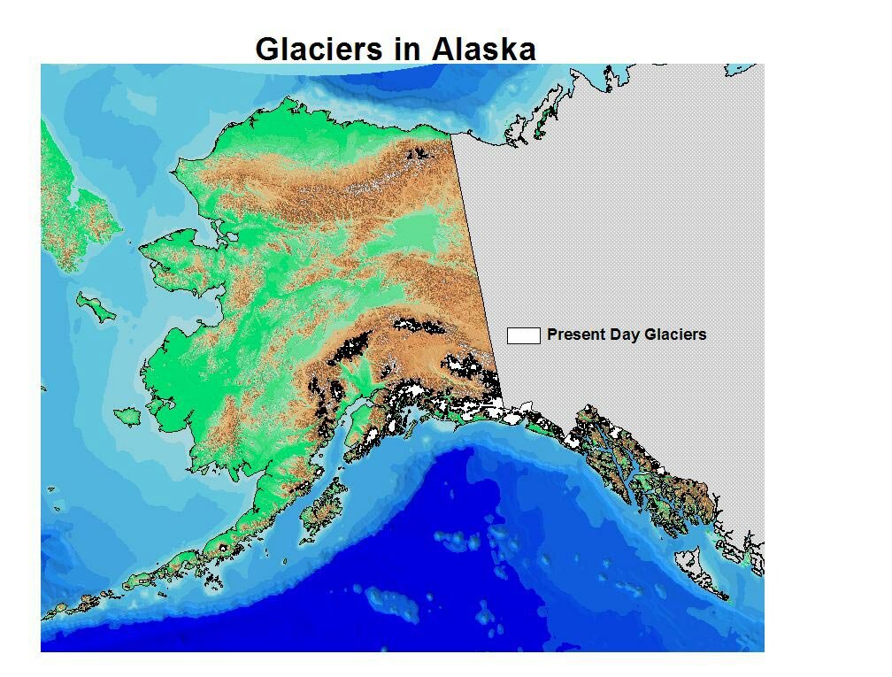 Figure PS.5 - Glaciers Today Why are glaciers found primarily in these areas? In order for a glacier to survive and thrive, it needs two things. First, it needs to have a sufficient supply of moistureboth to build up the glacier and to maintain it. That means glaciers are going to be located near a good supply of moisture. Alaskas coastal mountains are located in a region where air flow from the Pacific Ocean brings in a large amount of moisture. As the moist air is pushed against the mountains, it is lifted (called orographic uplift by geographers) and cooled with the result being snowfall. Second, to survive, glaciers need cold temperatures. Mountain peaks are colder than nearby sea level areas because temperatures cool with altitude. Generally, temperatures drop approximately 3.5 Fahrenheit degrees with every 1000 feet in altitude. So, a sea level temperature of 50° F would result in a temperature of 15° F at 10,000 feet. Thus, the high mountain systems of Southcentral and Southeast Alaska provide the cold temperatures for glaciers to survive. Native stories of the past speak of a period of more extensive glaciation in Alaska. Reports from Russian and later American travelers in Southcentral and Southeast Alaska describe glaciers in areas that are now ice free. Even in our own day we have seen glaciers such as the Columbia in Prince William Sound retreat over a mile in less than a decade. What is happening? Over the last 200-300 years Alaskas glaciers have been receding. Temperature conditions have changed, it is warmer, and air circulation has changed, thus altering how much and where precipitation falls. Global warming is a simplistic description of the environmental change that is occurring. Fifteen thousand years ago glaciers covered nearly half of Alaska and significant portions of North America, South America, Europe, and Asia. With all that moisture locked up in ice, sea level dropped over 300 feet below its level today. Consequently, the so-called Bering Land Bridge emerged as sea level dropped and Siberia and Alaska were joined by emergent land. Over the last several thousand years, glaciers have receded, interrupted by periods of stability and even expansion. What would happen to sea level if all of Alaskas glaciers were to disappear? Not much. World sea level would rise less than a foot. However, if that kind of environmental change were to occur, other world glaciers would also melt, which would cause significant flooding in coastal areas throughout the world. (http://www.ngdc.noaa.gov/paleo/parcs/atlas/beringia/) Hydrosphere: Rivers and Lakes 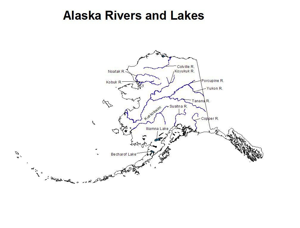 Figure PS.6 - Rivers and Lakes Alaskas largest river system, the Yukon, begins its flow in Canada, and continues through the Intermontane physiographic region of Alaska where it eventually flows into the Bering Sea. Alaskas other major river systems are (Figure PS.6). Alaskas largest lakes are found today in Southwest Alaska. The largest is Illiamna Lake (1,150 sq. miles or 2,979 sq. kilometers) followed by Becharof Lake (458 sq. miles or 1,186 sq. kilometers). Geologists have estimated that during the last major glacial period Glacial Lake Ahtna, in the vicinity of the Copper River Lowland, was thought to be larger in size than Lake Michigan is today (Figure PS.5). Hydrosphere: Oceans Alaska is surrounded by oceans on three sidesArctic Ocean to the North, Bering Sea to the West, and the Pacific Ocean to the South. Meeting these waters is Alaskas coastline which extends for 43,887 miles miles. This figure amounts to 64 percent of the entire U.S. coastline. The oceans have provided a great source of food for the peoples of Alaska for thousands of years. Shellfish, deep sea (demersal) fish, and anadromous fish have all provided, and continue to provide food, income, and a way of life for many Alaskans. Like much of Alaskas land area, the coastal waters of the Arctic Ocean, Chukchi Sea, and Bering Sea stay frozen for several months of the year, with ice extending into the Bristol Bay region. In contrast, the coastal areas of the Pacific Ocean remain largely ice-free during the winter allowing ocean-going vessels access to ports in Southcentral and Southeast Alaska. 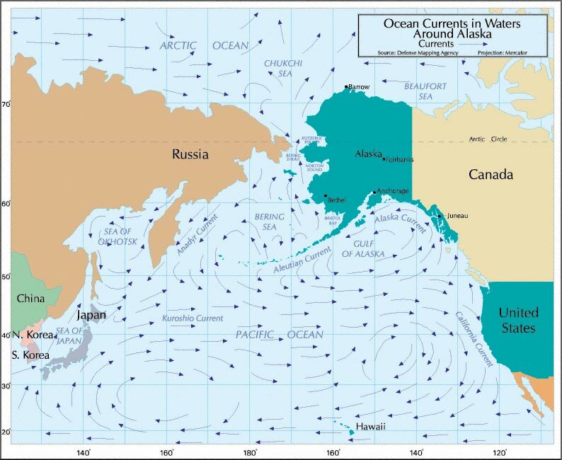 Figure PS.7 - Ocean Circulation In the Bering Sea, water flows northward along the Alaska coastline through the Bering Strait and into the Arctic Ocean. Waters from the Arctic Ocean flow southward along the Russian coastline via the Anadyr Current. Biosphere & Ecoregions Plants and animals make up the biosphere. How they are distributed on Earths surface is largely a reflection of the broader environment. Consequently, there has been a concerted effort by environmental researchers to develop Ecoregions which reflect not only general plant and animal distributions but also the associated geomorphic and climatic features. Here we can see how two geographic concepts, region and scale, are used to interpret these complex environmental details. At the most general level, the state is divided into two Domains which represent two sub continental climatic zones. Next, the Domains are divided into 5 subunits called Divisions which are based on lifeforms such as meadows and forests. In turn, Divisions are divided into 10 subunits called Provinces which use broad vegetation types for their categories. Finally, Provinces are divided into 34 Sections identified primarily by geomorphic and topographic features. To illustrate this system, we can use the example of the Ahklun Mountains in Southwest Alaska. This Section is described as having these features: This coastal group of rugged steep-walled mountains spans two extensive wetland complexes (Yukon-Kuskokwim Delta and Bristol Bay Lowlands) along the southern Bering Sea. Here strongly deformed sedimentary and volcanic rocks are cut by great northeast-trending faults, including portions of the Denali fault. Here mountain glaciers coalesced during the Pleistocene and carved many broad U-shaped valleys. On the south side of the mountains, these valleys subsequently filled with water forming large finger lakes. These lakes have resident rainbow trout and nurture abundant runs of sockeye (red) salmon during the summer. Mountain soils have formed in very stony and gravelly colluvium over bedrock, whereas valley soils have formed in glacial till. Dwarf shrub and lichen tundra dominates mountain crests and upper slopes where permafrost is discontinuous. Shrubs (willows, birches, and alders) become progressively more abundant and robust at lower elevations as permafrost becomes more fragmented. In valleys, shrublands are punctuated by sedge-tussock tundra meadows (on very wet areas) and mixed forests. Moose, beavers, and arctic hares thrive in these shrubby habitats. Great numbers of gregarious walruses and sea lions haul out in along the rocky beaches while seabirds patrol the skies. The climate is moist polar with some moderation by the Bering Sea. At this latitude, ice normally spans the Bering Sea in winter, allowing access for cold Siberian air. (Narrative Descriptions for the Ecoregions of Alaska and Neighboring Territories. 2000. G. Nowacki (USFS), P. Spencer (NPS), T. Brock (USFS), M. Fleming (USGS) and Torre Jorgenson (ABRI). The Ahklun Mountains are located within the broader Bering Sea Tundra Province, and more general Arctic Division of the sub continental Polar Domain. 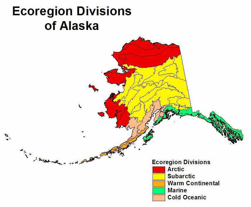 Figure PS.8 - Ecoregions of Alaska Collection Name: Nowacki, Gregory and Terry Brock. 1995. Ecoregions and Subregions of Alaska, EcoMap Version 2.0(map). USDA Forest Service, Alaska Region, Juneau, AK. Case Study: Permafrost Permafrost is a subtle element of Alaskas landscape. It occurs below the surface, and it shapes minor forms on the land surface. Yet, it is found in nearly 80% of Alaska and it has a profound impact on how we build and maintain our physical infrastructureroads, rail, pipelines, bridges, homes, commercial buildings, and factories. It is a reality for much of the polar world (north and south) as well as high mountainous areas such as Tibet. It occupies approximately 20 percent of the worlds land surface area. What is permafrost? It is ground that has been frozen for two or more years. The definition includes rock, soil, and, of course, ice, whose temperature is below 32°F (0°C).  Figure PS.9 - Permafrost Why should one be concerned about permafrost? Building on it could cause the permafrost to melt which could cause the building to partially sink. Similarly, roads in permafrost areas can cause the subsurface to melt resulting in road depressions and expensive repairs. Should recent trends in warming average temperatures in Alaska continue, permafrost areas could destabilize and generate new challenges for Alaskas maintenance and construction industries.
|
||||||||||||||||
|
