
|
|
||||||||||||||||||||||||
|
The Geography of Alaska
Alaska's Location
Relative location tells us where something is in relation to other places. In the 1930s, General Billy Mitchell claimed that Alaska was the center of the world. Of course, at the same time, most Alaskans thought of their semi-isolation and considered their territory as being near the edge of the world. Absolute location refers to a geographic address. For many Alaskans their mailing address is one way they answer where exactly they are at. Of course, that location might be a post office box address: P.O. Box 1, Any City, Alaska. That address places those people at the local community U.S. Post Office. For others, that address might be a street address: 100 West Main Street, Anytown, Alaska. We will look at other ways of identifying exact location below. Together, these location systemsrelative and absoluteprovide us with a way of understanding where we are in the world. Relative Location: Where is Alaska? What could General Mitchell possibly be thinking of when he made his claim that Alaska was at the center of the world? General Mitchell had spent part of his military career in Alaska. He was involved with the Signal Corps so he knew something about the territory. He also had a fascination with aircraft and felt that the U.S. military needed to bolster its air force. (At the time, there was no U.S. Air Force.) 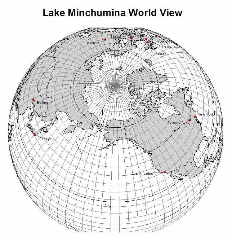 Figure L.1 - Alaska from Space. Orthographic projection. We can view Alaskas relative location from a number of perspectives. For simplicity, we will identify Alaska as part of the North Pacific, the Northern world, the North American continent, and the United States. North Pacific. The commonly accepted theory of the initial occupation of Alaska is that people migrated from Asia over different periods of time. One advantageous time period was during the Pleistocene glacial period when the vast area of Beringia existed. People could move along the coastline from one continent to the other as the water barrier was non-existent. Of course, even the waters of the Bering Strait have proven to be no real barrier to Inupiat and Chukchi peoples who have moved back and forth between North America and Asia for centuries. 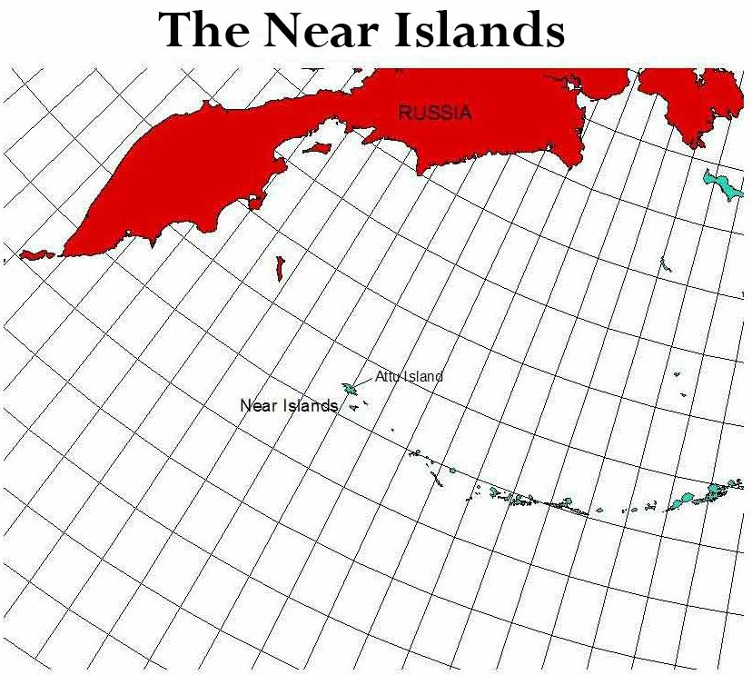 Figure L.2 - The Near Islands of Alaska 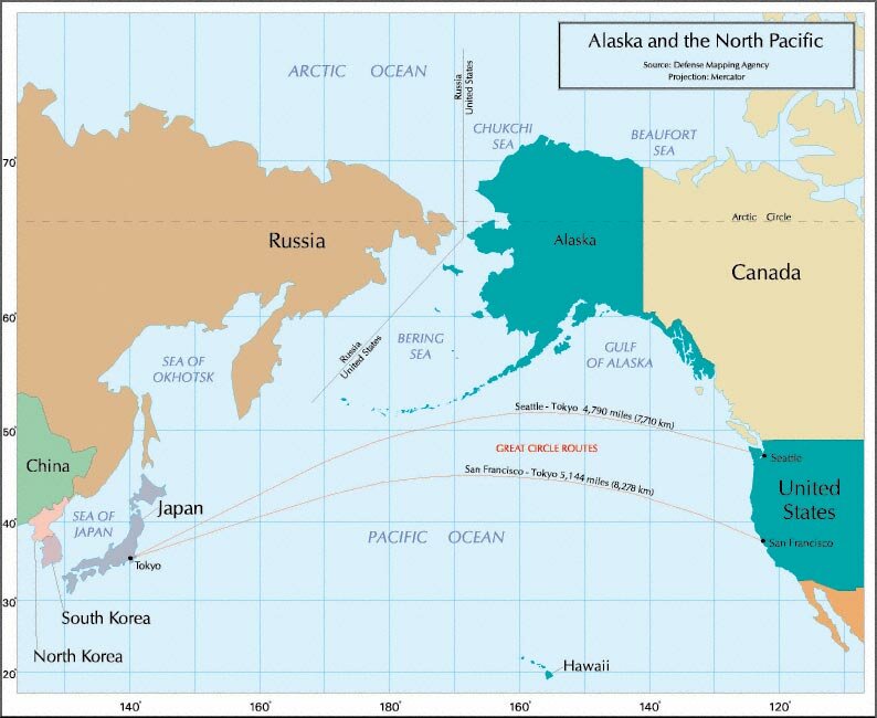 Figure L.3 - Alaska as part of the North Pacific region Northern World. If we look at Figure L.1 again, we can see how Alaska is part of the Northern world. We share the Arctic Ocean waters with Russia, Sweden, Norway, Greenland, and Canada. The Arctic Circle, an arbitrary line of latitude at 66.5° North, crosses all of the above countries plus Finland (which is blocked from the Arctic Ocean). Thus, all of these countries (and Alaska) share a similar environment. International conferences on changing northern climate and permafrost draw participants from across the northern world. Similarly, institutions have been formed that are founded on the shared northern situation. Examples include the Arctic Council (amongst countries) and the Northern Forum (amongst northern regional governments such as Alaska). This is a good place to pause and consider Alaskas relative size. Alaskans are proud of the size of their state589,000 square miles or over three times the size of California. Yet, in the context of the northern world, its size is modest, being exceeded by regions such as the Northwest Territories and Nunavut in Canada, Greenland, and Sakha in Russia.  Figure L.4 - Alaska as Part of North America United States. Since 1867, of course, Alaska has been part of the United States, and since 1959, it has been a state within the United States. Alaska accounts for 17 percent of the total U.S. area and 64 percent of the U.S. coastline. Along with Canada, the U.S. borders on the Arctic Ocean, Pacific Ocean, and Atlantic Ocean. Where in Alaska? We have looked at Alaska relative to other places and regions. But within Alaska we can see how a relative location perspective can be very helpful. Imagine you are a high school student from California attending a meeting or a sporting event with students from other areas of the western states. You happen to sit at a table for dinner with students from Barrow, Fairbanks, and Ketchikan. To start the conversation, you ask the polite question, Whats it like in Alaska? Image the different responses you would get! You might be inclined to ask if the three students were, in fact, from the same state. The shear size and distances between places account for the great differences between places. Additionally, there are great environmental differences between these areas that are separated by mountain ranges and 15 degrees of latitude. 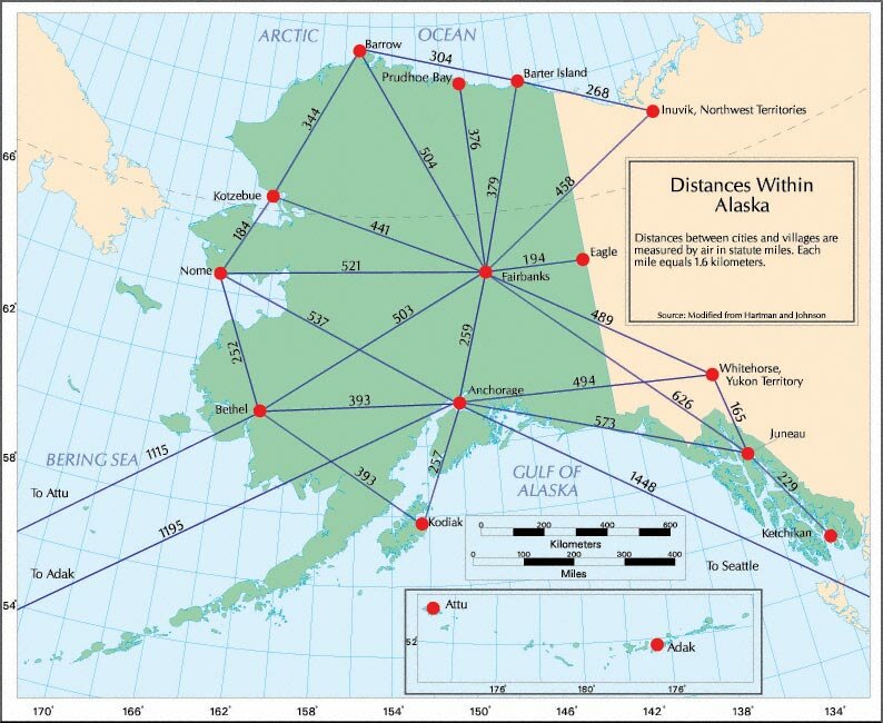 Figure L.5 - Distances in Alaska 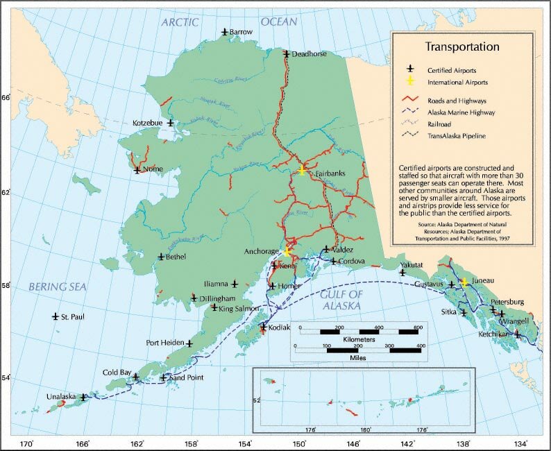 Figure L.6 - Alaskas Transportation System 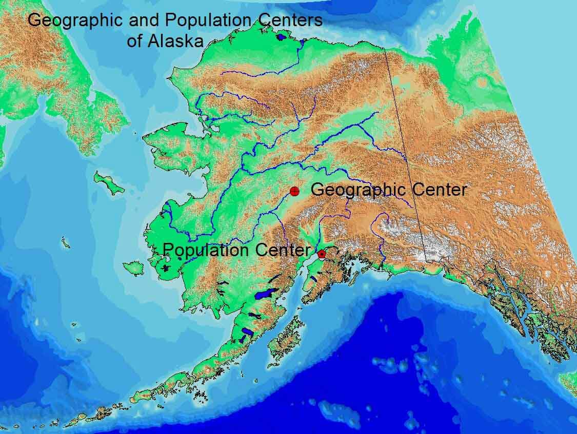 Figure L.7 - Alaskas center points. Absolute Location In contrast to relative location which compares a location with what surrounds it, absolute location refers to exact location. We can express this location mathematically using different geographical systems. Latitude and longitude is the most commonly used system. It is based on degrees of latitude (90° north and 90° south with the center at the Equator) and longitude (180° east and 180° west calculated from the Prime Meridian). This location system divides each degree into 60 minutes and each minute into 60 seconds. If you wanted to identify the National Park Service headquarters for Denali National Park it would be: 63° 43 20 N, 148° 57 48 W According to this system, Alaska has the distinction of being in both the eastern and the western hemisphere. The Rat Islands and Near Islands lie in the Eastern Hemisphere. Thus, Alaska is sometimes the subject of trivia game questions: What is the northernmost, westernmost, and easternmost state of the United States? Using this system, we can see that Alaska extends over a vast area. Here are its key extents: South: 51° 13 N. at the tip of Amatignak Island in the Aleutian Islands While the distance between the northern and southern points is 1,420 miles (2,285 km) and the distance between the eastern and western points is 2,400 miles (3,862 km), Alaska definitely does not have a neat rectangular shape. The Aleutian Islands extend out so far from the main body of Alaska that they are rarely shown on maps in their proper location. Not surprisingly, Alaskas 6,640 miles (10,700 km) of coastline amount to over half of the total coastline of the United States. Alaskas size, by U.S. standards, is enormous. It accounts for 16 percent of the U.S. area. More specifically, Alaskas 589,194 square miles (1,525,953 km2) consists of 571,951 square miles of land (1,481,296 km2) and 17,243 square miles (44,658 km2) of inland waters.
|
||||||||||||||||
|
