America's Territory
Ten years after the purchase of Alaska, the United States knew little more than the Russians had about the territory. Gold discoveries and interest in setting up salmon canneries increased interest. Traders and prospectors wanted access to fur and mineral resources. With more activity, there was a need for accurate maps and charts of coastal and inland areas. In the late 1800s, researchers were interested in Native people. A growing number of people wanted information about Alaska's resources, geology, and environment.

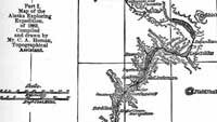
Part I. Map of the Exploring Expedition of 1883.
Title and description taken from map. Compiled and drawn by Mr. C.A. Homan, Topographical Assistant.
The Chilkoot Trail went through Canadian territory, so there was a call for a year-round route to the Yukon River that did not cross foreign territory. The Copper River valley seemed as though it might be such a corridor. Lt. Henry T. Allen successfully ascended the river in 1885. He chose not to travel with horses and to carry little food. He and his men might have starved if Ahtna chief, Nicolai, had not shared his people's meager food with the explorers. Nicolai also showed Allen copper nuggets. After leaving Nicolai's territory, the Allen party continued north. The party reached the Tanana River valley, and followed the river to where it joins the Yukon. Allen and one of the men traveled overland to the headwaters of the Koyukuk River and descended it. The party reached the mouth of the Yukon. In five months Allen explored 1,500 miles of wilderness and charted the courses of the Copper, Tanana and Koyukuk rivers. This expedition made significant contributions to the understanding of Alaska's geography.
In Northwest Alaska, the Navy and the Revenue Marine Service explored along the Kobuk River in 1884. The expeditions sought information on resources, including deposits of jade, and tried to find a river that flowed north to an ocean filled with ice. They found the Colville River. The expeditions collected information on the natural history and made maps.
By 1900 the important mountain ranges of Alaska had been outlined and the major rivers traced. That year the U.S. Geological Survey took over from the Army as the major government agency in charge of scientific exploration of Alaska. Each year teams of geologists worked around the territory, made maps, took photographs, kept field notes and wrote reports. These are all e invaluable sources of information about all parts of the territory and its resources.